Image Courtesy of
Allen Denoyer
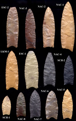
Image Courtesy of
Larry Lindahl
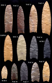
Clovis Points from
the San Pedro Valley
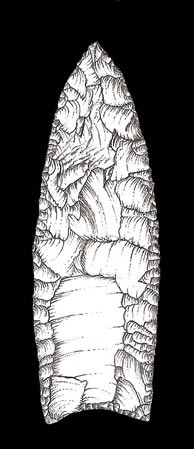
Image Courtesy of the
C. Vance Haynes
Cast Collection
|
|
The Arizona Paleoindian Point Survey
|
|
Purpose:
The purpose of the Arizona Paleoindian & Paleoarchaic Projectile Point Survey is to document
the occurrence and distribution of distinctive projectile point (spear/dart point) types in order to
better understand the prehistoric human colonization of Arizona. |
|
Scope:
The Arizona Paleoindian & Paleoarchaic Projectile Point Survey is a long-term project to
locate public and private artifact collections containing projectile point types that are
radiocarbon dated between roughly 11,500 and 8,000 years ago. These include fluted
Paleoindian point types such as Clovis and Folsom, unfluted point types such as Plainview-
Goshen, Agate Basin, Hell Gap, Scottsbluff, Eden, and Frederick-Allen, and Paleoarchaic point
types such as Lake Mojave, Silver Lake, and San Dieguito. Examples of these projectile point
types are provided on Page 2 of the information sheet.
AZ Paleoindian Point Survey Information
AZ Paleoindian Point Survey Recording Form
AZ Paleoindian Point Survey Recording Form Example |
Methods and Background:
The Arizona Paleoindian & Paleoarchaic Projectile Point Survey is unique in the history of
projectile point surveys in Arizona because it is based on public outreach and voluntary
disclosure rather than word-of-mouth or literature reviews. This systematic, “bottom-up”
approach is facilitated by the widespread distribution and on-line presence of a Paleoindian &
Paleoarchaic Projectile Point Data Form at http://pidba.utk.edu/arizona.htm.
Persons who are interested in the use of state-wide and continental Paleoindian projectile point
databases to reconstruct human colonization are referred to the Paleoindian Database of the
Americas (PIDBA) at http://pidba.utk.edu. |
Scientific Ethics:
The survey organizers flatly discourage the unauthorized collection of cultural resources from
public, tribal, or private lands. The applicable state and federal laws regarding archaeological
discoveries and historic preservation can be found at the links provided below. The
information gathered by this survey is intended for academic research purposes only, however,
and will not be shared with agents of the local, state, or federal government without the express
consent of the survey participant. Anonymous reports (recorder contact information withheld)
will not be included in the survey in order to minimize the potential for fictitious claims.
Arizona State Museum:
http://www.statemuseum.arizona.edu/crservices/legal_links.shtml
Arizona State Historic Preservation Office:
http://azstateparks.com/SHPO/etiquette.html
Bureau of Land Management:
http://www.blm.gov/az/st/en/prog/recreation/rockhnd/fossils.html |
|
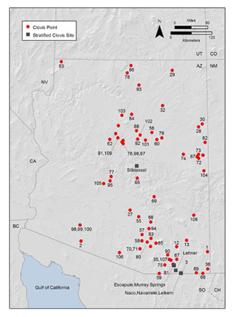
The Distribution
of
Recorded
Clovis Points
in Arizona
Map created by
Saul Hedquist
Based on data from:
Haynes, Jr., C. Vance (2011) Distribution of Clovis Points in Arizona and the Clovis Exploration of the State.
Kiva 76(3):343-367.
|
|
 |